Chief
Ladiga Trail
Piedmont to Jacksonville to Weaver
Alabama
A Rails-to-Trails Ride
![]()
|
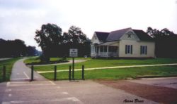
This trail is not an actual mountain bike trail, but is just too good not to list here. It is a Rails-to-Trails type ride. From just east of Piedmont, Alabama, through town, and on west to Jacksonville a narrow asphalt ribbon follows an abandoned railroad bed through woods and neighborhoods. It crosses streams and a few roads. Some of the bridges are new. Some are improved railroad trestles, and all are great. On the other side of JSU campus the ribbon takes up again and goes to the town of Weaver. Signs point the way to parking there. You can walk, run, bike, roller-blade, or what ever. No stinkin' engines allowed. The paved trail is almost 32 miles long. There are no steep grades on it so it is suitable for all. It is a great family ride and it is great for a hammer head who wants to ride a good level straight ride. It follows along hi-way 21 from Piedmont to Jacksonville. There are several good places to park in Piedmont with signs pointing the way. The best place and most popular trailhead in Piedmont is the Eubanks Welcome Center and is staffed most of the time. Prime parking with water and restrooms is the old Train Depot on Mountain Street in Jacksonville. There is a large parking area at Germania Springs Park. The Western end of the trail is now at Woodland Park near Anniston, Alabama. The Eastern terminus is the Georgia state line.. | ||||||||||||
![]()
If you have not ridden this rails-to-trails, it is a "must ride".
![]()
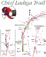
Maps of the Chief Ladiga Trail
| Instructions for viewing and printing
map: The map in on two sheets. To view either half of the map simply click the thumbnail or link under the map. To print the map you may have to set the page properties for your browser if part of map is missing. |
 |
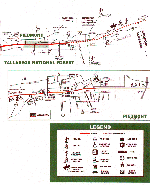 |
| printing instructions........ | Map Left Half - 187kb | Map Right Half - 192kb |
![]()
Some of the information on this page and the trail maps were obtained from a brochure which was funded by a grant from the Calhoun County Commission. All information used by permission and is placed here to promote the use and expansion of the trail project. Thanks also to the East Alabama Regional Planning and Development Commission, P.O. Box 2186, Anniston, AL 36202. And to Mr. Jack E. Plunk, Principal Planner, for his assistance in obtaining information about the trail.
![]()
Related Links
Rails-to-Trails - national organization home page. Info about
other projects and trails.
Silver Comet Trail - rails-to-trails from Smyrna to Rockmart
that connects with the Chief Ladiga Trail at the Georgia line.
Biking Weatherman's Page - This site has many good photos of the trail
and country surrounding it and maps second to none.
 |
This page is part of Aaron's Alabama Mountain Biking © Click the Flag to go there |