Sipsey
Wilderness Area
Bankhead National Forest
![]()
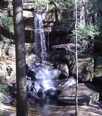 |
The Sipsey Wilderness Area is located in the Bankhead National Forest. This is in North Alabama near Double Springs in Winston and Lawrence Counties. The wilderness area is unique because of the canyons which comprise much of it. It is named for the Sipsey Fork of the Black Warrior River. The Sipsey Fork is the main drainage from the area and runs into Lewis Smith Lake. The feeder creeks and smaller streams which run into the Sipsey usually run cold and clear. I have heard it said that there are 100 water falls in the area, but I do not believe there are that many. It is a different kind of place where fording cold streams is part of most hikes on the forty miles of trails. |
| Sipsey Wilderness Area
General Information The Sipsey Wilderness is about 26,000 acres. It is the largest wilderness area in Alabama. There is much information available online about the area. I will try to provide some additional information here and links to other sites which I think are reliable. My main goal here is not to provide exact information about the area, although I will do that, but to help you find it if you have never been and help you make decisions about where to go and what to see and do there. |
Sipsey Trail Map Trail Miles Chart Sipsey Photos Printable Trail Map.pdf 4MB Printable Trail Guide.pdf Locator Map low resolution Locator Map high res. pdf Other Site Links at Bottom |
![]()
Sipsey Wilderness Area Trail Guide
| PURPOSE: The purpose of this guide is to help those who know little about the SWA (Sipsey Wilderness Area) plan a hiking or backpacking trip. SCOPE: Some of the interesting features of certain areas and trails are pointed out. The list of points of interest or terrain features is not meant to be complete, but only a guide. WHAT IS THERE: In the center of the SWA the Sipsey Fork of the Black Warrior river runs through the Sipsey Gorge with vertical and near vertical cliffs on the North side of the river. This is indeed one of the drawing cards which makes the SWA popular and unique. The river normally runs cold and clear. It varies from slow sections with sandy beaches to rock and boulder strewn areas which add to the beauty and uniqueness of the area. The river is filled with bream and bass, though the clear water may make them difficult to catch. What is said to be the largest tree in the state is located in the Bee Branch Area of the SWA. It is a Yellow Poplar tree often called the "Champion Tree". Hemlock trees also thrive here. This is the southern most range of the Hemlock tree and the SWA is the terminus point for this tree in the Appalachian range. Because of the geological makeup of the area, there are many waterfalls here and some of them are located on the trails. FORDS: There are several trails which necessitate wading. Crossing at normal water levels is neither difficult nor dangerous, however at higher water levels it can be both. The fords are less than knee deep and the bottom is soft and sandy. They are no more than an inconvenience which adds to the wilderness experience. These are some of the fords you may cross. Trail 202 cresses the river where it joins 209. There are three fords on 209, the first is near the East end where it crosses Borden Creek. The second is crossing Bee Branch and the last across Sipsey Fork to join 201. There is also a ford where trail 201 and 206 join. ERRORS ON THE MAPS: Many of the maps for this area have errors on them as to what you will actually find on the SWA. The most accurate is published by Cart-O-Craft. I recommend you get this map. It is not available directly from them online, but is available at many outdoor shops and can be purchased from many web sites. It will cost your from $6 to $11 but is a bargain form a plastic coated waterproof map. The topographic maps available from USGS do not have the trails on them. The map you can get from the ranger station in Double Springs is very small. This is a wilderness area and few if any trail markers remain once you leave the trail head. COMMENTS: I am in no way associated with the Forest Service or any agency and what ever you read here are my own biased opinions. Have a great hike. Respect others. Be careful with fires. Treat all your drinking water. Pack out all trash. Enjoy God's creation, there is a lot more there than trails. Leave it a wilderness for me to enjoy; Aaron Bruce. TRAILS: 200 - The North end of this trail starts at the bridge crossing Borden Creek. This bridge is blocked to vehicles, but you can drive to in on FS road 224. The South end of the trail joins 209 at the ford of Borden Creek. Soon after the trail leaves the parking area at the bridge, the trail goes under a rock which is difficult or next to impossible to negotiate with a frame pack. If you do not have a large pack this is a cool feature on this trail. If you have a large pack it is a small problem. If there are two people you can hand your pack past the narrow tight squeeze. Or you can climb over the rock, but that is a hazardous route. The safest and easiest way around this obstacle with a large pack is to enter the creek and wade around it. There is a large camping area about one half mile North of the jct with 209. 201 - This trail and 202 start from the trail head, a paved parking area located on Cranal Road. The trail starts following an old road and goes through typical southern forest on its way to the Sipsey Fork. There is a ford at the Northern end of this trail no matter which way you go. You must ford to join 206 or 209. 202 - It starts from a common point with 201. 0.4 mile from trail head parking lot on Cranal Road the trail takes the right fork. This trail also follows an old road and starts out ordinary, but turns rather beautiful as it nears the Sipsey Fork. There is a nice water fall beside the trail when there is enough water flowing in the unnamed branch which creates it. This trail in conjunction with 201 and 209 make a nice loop. NOTE: during midsummer and fall, ticks infest parts of this trail. It is the worst place I have ever seen. I feel it should be avoided from mid June until cold weather. This is a real nice loop for other times of the year. 204 - This was once the most used trail in the SWA before the blocking of FS road 224 to vehicles when the wilderness area was doubled in size. It leads to the Bee Branch Scenic Area. This trail head may not be marked as well as the others. Trail 204 starts from FS road 224 which is blocked to vehicles at Borden Creek Bridge and is now trail 224. This trail as it is marked on older FS maps is incorrect. There is a fork in this trail just less than one mile from the trail head. The left fork is on all maps, but the right fork, which goes to Bee Branch may not be. I will call it 204A and deal with it next. 204 goes to the left at the fork and is an easy trail as it passes through hardwood forests which also contain large hemlock trees. It has some nice views of the area just before it descends into the gorge and joins trail 209. Trail 204 or 204A in conjunction with 209, 224 and 202 make a nice loop. 204A - This trail may not be on your map. Just less than one mile down trail 204 there is a fork at a trail marker. The trail to the right, trail 204A, leads to the Bee Branch Scenic Area. In this area there are two water falls, a huge yellow poplar tree which is said to be the largest in the stare, and many unique rock formations. All of which are visible from one place. This area was once very popular as a day hiking area, and saw heavy use on weekends. You will not want to miss this area of remarkable natural beauty. The trail is steep where it descends into the gorge of Bee Branch and care should be used when wearing a loaded back pack. Because of the heavy use this area gets, the trail South may be difficult to find. It goes down stream and stays on the left side of the branch. Almost any trail you take will turn into the correct one and lead you down the branch several miles to trail 209 and the Sipsey Fork. There are several good camping spots along this trail before it gets to trail 209. If you are traveling on trail 209 this trail is not marked but is the trail which goes north from 209 along the East side of Bee Branch. If you do not take this trail you will ford Bee Branch to go North on 209. 205 - I do not know if this trail is still open. I will field check it. The trail head for 205 is on 224 about one mile from the trail head of 204. This trail follows an old road then descends into a beautiful hemlock forest near the river. Trail 205 was heavily used in the past, but the blocking of FS 224 may have caused it to be lost. 206 - Often called the Thompson Creek Trail, it starts where FS 208 is blocked at the trail head parking area. This trail is a very easy walk and crosses a small section of private land. There is a sign which restricts use to a ten feet wide trail right of way. About 1.5 miles down the trail South from the trail head there is fork in the trail. The right fork closely follows Thompson Creek. The left for leads up the branch to a water fall and an interesting area with large overhanging rocks. It looks as if it belongs in the Smoky Mountains. Both trails later rejoin. There are many place to camp along this trail some larger campsites are nearer the Sipsey Fork. 209 - The trail head is in the Sipsey River Recreation Area located where Cranal Road, Lawrence County Rd 6 and Winston County Rd 60, crosses the Sipsey Fork. About 1/3 mile North of the start. It fords Borden Creek. This is a very nice trail as it follows along the river. A striking water fall is right on the trail where it crosses Fall Creek. There are nice camping spot before 202 joins it. There are a few decent camp spot between where 202 and 204 join trail 209, four very nice camping places lie between junction of 204 and the ford at Bee Branch. These are large enough for at least three tents each, and two of the would hold more. These camp site are heavily used and care should be taken to make as little impact as possible on them. They all have good access to the river to get water, good swimming places, and decent fishing near by. Where 209 crosses Bee Branch, sometimes can be a ford and sometimes can be jumped across, depending on how much rain there has been. The trail is very beautiful from Bee Branch to its end as you walk through a young hemlock forest. There are some places to camp on this section of the trail also. Several springs are located on this section. A notable one is above the trail under a large overhanging rock and has a clear trail leading up to it. Trail 209 does continue through the section of private land. Because the trail does not actually end and cross the river as most maps show, the place where it fords the Sipsey Fork can be difficult to locate. A difficult to see trail marker marks the ford if it is still there. You can continue on 209 to where it joins 206 without fording the Sipsey twice as some maps show. 207, 208, 210, 223 - I have not yet walked these trails, but will post information for them as soon as I do. 224 - This is the old Forest Service Road 224 and follows a ridge top after ascending from the bridge at Borden Creek. Nature is taking the road back. After the blizzard of 1993 there were hundreds of trees across this road. Most of them have rotted out. This trail is open to horse rider use so it tends to wash worse than some of the other trails. When this road was open to vehicles FS 224 was a key route to accessing the North side of the SWA. Now this trail is a key trail to loops in conjunction with the other trails of the SWA. BLOCKED ROADS: Some of the blocked roads South of the Sipsey Fork are not easily found since they have been blocked for over 25 years. The ones which are now trails 201 and 202 are easy to find because of much foot travel. Others will not be so easy. The blocked roads north of and including old FS 224 and FS 208 were blocked in 1990 and are clear and open to foot and horse travel only. FS 224 and FS 208 once formed the Northern border of the SWA and now run through the center of it. Some of these blocked roads on the northern half will make good walks and hikes, but some follow ridge tops and water is not available on them. |
 Borden Creek Trail |
Wilderness.net
- Home Wilderness.net - Sipsey Wild South - formerly Wild Alabama The Wilderness Society - Home Sipsey Wilderness Hiking Club - The Best Resource Some of the extended links may change so I have listed the links to the home page on these sites. |