Cheaha State Park Mountain Bike
Trail
Cheaha Express
![]() I read that the bike trail here was cleared and was in good
condition in December of 2020. I have not been to check it out. It was once a good ride. It starts on the right side of the road
right at the entrance gate to the state park. Payment is on the honor system most of the
time. The actual length of the system of trails are approximately 10 miles. Because of loops on the trail which beg to be repeated, an
actual ride will probably be more. There is certainly enough trail here for a good ride.
I read that the bike trail here was cleared and was in good
condition in December of 2020. I have not been to check it out. It was once a good ride. It starts on the right side of the road
right at the entrance gate to the state park. Payment is on the honor system most of the
time. The actual length of the system of trails are approximately 10 miles. Because of loops on the trail which beg to be repeated, an
actual ride will probably be more. There is certainly enough trail here for a good ride.
![]() Camping in Cheaha State Park would make a good central
location for a great week of Mountain Bike riding. There are four (4) trail
systems in this area. This trail is not far from
three other trail systems. One is McClellan on the old fort, Henry Farms in
Jacksonville, and the other is on Coldwater Mountain. All four of these trails
are separated by a drive of 20 to 40 minutes. The trails on these 4
systems vary from beginner level trails to Black Diamond difficult.
Camping in Cheaha State Park would make a good central
location for a great week of Mountain Bike riding. There are four (4) trail
systems in this area. This trail is not far from
three other trail systems. One is McClellan on the old fort, Henry Farms in
Jacksonville, and the other is on Coldwater Mountain. All four of these trails
are separated by a drive of 20 to 40 minutes. The trails on these 4
systems vary from beginner level trails to Black Diamond difficult.
![]() Parking and Fees
Parking and Fees
There is plenty of parking in the parking lot above the store at the
entrance to Cheaha State Park. I prefer to ride from there and the return will
be downhill. The start of the trail is on the right side of the road at the
entrance gate and fee building for the park. The start of the trail should be
plainly marked. I don't know what the fee per person is. When I rode there I
would always drop it in the
honor system box at the gate as there has never been anyone there when I have
ridden, always early in the morning.
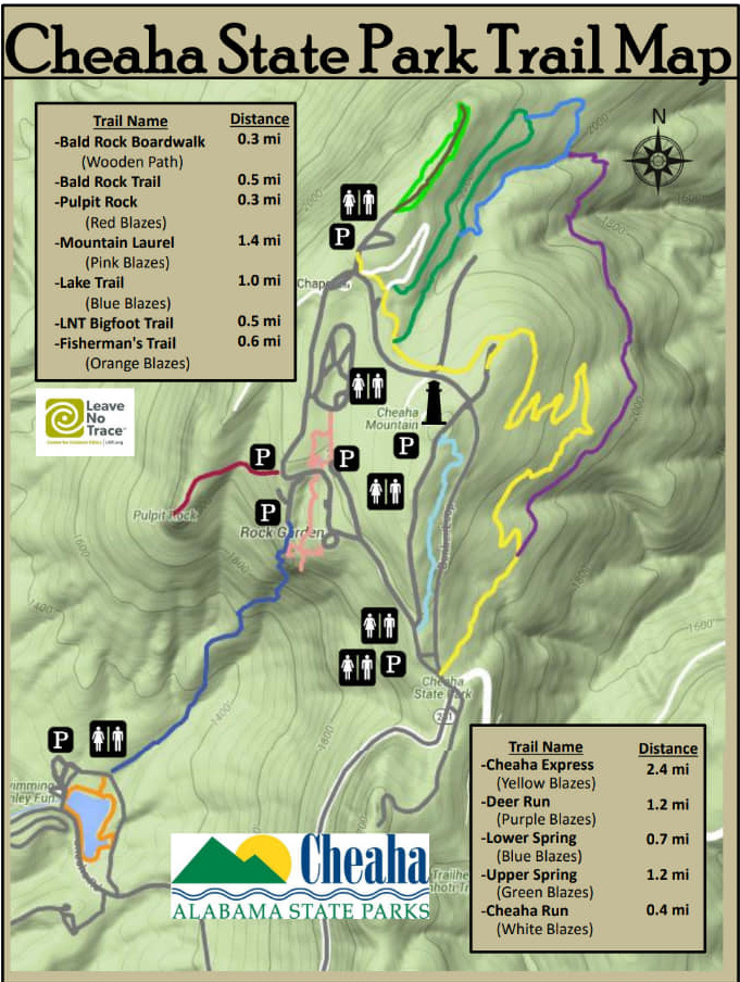
![]() Trail Map
Trail Map
Click on the thumbnail for a printable map of the State Park and the Trails
Aaron's Alabama Mountain Biking
![]()